

In 2008, surveyors in Wales used GPS to remeasure a hill that earlier surveys put at 1,998 feet. They found it stood 2,000 feet and 6 inches tall. That half foot turned a hill into an official mountain.
The difference between a mountain and a hill is simple in everyday speech: a mountain is bigger, steeper and rises higher above the land around it. The hard part is that no single official number draws the line, and the old U.S. rule was dropped more than 50 years ago.
The USGS says the U.S. Board on Geographic Names once used 1,000 feet of local relief as the dividing line, but even that was abandoned in the early 1970s.
This guide shows the rules people have used, the three ways to measure a landform, and a worked example that tests real summits against the 2,000-foot rule. You’ll also see why some “hills” are taller than some “mountains.”
Quick Info
| Topic | Detail |
|---|---|
| Short answer | A mountain rises higher and more steeply above its surroundings than a hill, but no official height separates them |
| Old U.S. rule | 1,000 feet (305 m) of local relief, dropped in the early 1970s |
| Common UK and Ireland rule | About 2,000 feet (610 m) above sea level |
| Scientific approach | UNEP-WCMC uses seven classes based on elevation, slope and local relief |
| Three measuring sticks | Height, local relief and prominence |
| Common mistake | Assuming one official number exists |
| Reading time | About 10 minutes |
What Is a Mountain, and What Is a Hill?
Let’s define each term, then compare them side by side.
What is a mountain?
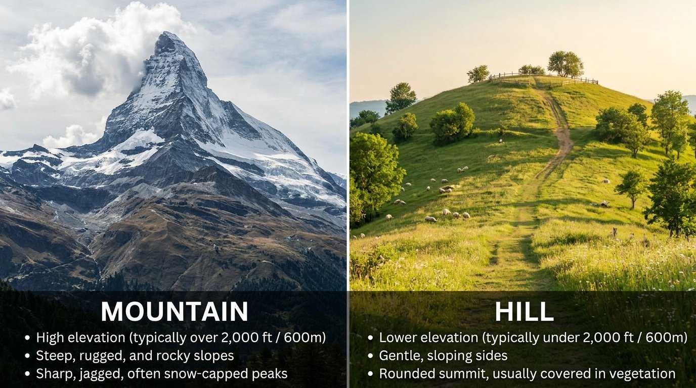
A mountain is a landform that rises prominently above its surroundings, with steep slopes, a small summit area and a lot of local relief. That description comes from Britannica, which also admits the word has no standardized geological meaning.
Mountains form in a few main ways: volcanoes build them from erupted magma, folding and faulting squeeze and lift the crust, and hot, expanded crust can stand high. Erosion can also leave behind older high ground as “residual” mountains.
What is a hill?
A hill is a lower, gentler rise. It usually has softer slopes and a rounder top, and it often stands alone instead of in a long chain.
WorldAtlas lists four kinds of hills: tors (rock exposed on top), buttes (flat-topped), drumlins (long hills shaped by glaciers) and puys (volcanic cones).
Mountain vs hill at a glance
| Feature | Mountain | Hill |
|---|---|---|
| Height | Usually taller, with no official minimum | Usually lower, with no official maximum |
| Slopes | Often steep | Often gentle |
| Summit | Often small and rocky or sharp | Often rounded |
| Setting | Often part of a range | Often stands alone |
| Common origins | Volcanism, folding, faulting | Erosion, glaciers, small volcanic cones |
These are tendencies, not rules. Plenty of landforms break them.
Why There Is No Single Rule
Governments and scientists have tried several cutoffs. None stuck everywhere.
On the U.S. side, the USGS notes that “broad agreement on such questions is essentially impossible,” so no official feature classification standards exist. In the UK, the Ordnance Survey used more than 1,000 feet before the 1920s. Geography Realm reports that it now defers to local custom but generally uses about 2,000 feet (610 m).
| Rule | What it measures | Threshold | Status |
|---|---|---|---|
| U.S. Board on Geographic Names | Local relief | 1,000 ft (305 m) | Dropped in the early 1970s |
| UK Ordnance Survey (older) | Height | 1,000 ft | Abandoned in the 1920s |
| UK Ordnance Survey (current practice) | Height above sea level | About 2,000 ft (610 m) | Defers to local custom |
| UNEP-WCMC mountain classes | Elevation, slope, local relief | Seven classes, for example more than 300 m of relief within 7 km for land at 300 to 1,000 m | Used in global mapping |
The last row comes from the UN statistics metadata, which lists the Kapos classes. Land above 2,500 m counts as mountain by elevation alone, so scientists don’t depend on one threshold either.
The 3 Measuring Sticks: Height, Relief and Prominence
People mix up three different measurements. Keeping them apart clears up most arguments.
Height (elevation)
Height is how far the summit sits above sea level. It is the number on most maps and signs.
It isn’t always positive. Our guide to why the Dead Sea is so salty explains a lake sitting about 430 meters below sea level, which shows that sea level is only a reference line.
Local relief
Local relief is how far the summit rises above the land around its base. Subtract the base elevation from the summit elevation.
That is the same idea as the range in statistics: highest value minus lowest value. For example, a summit at 1,450 feet with a base at 300 feet has 1,150 feet of relief. Under the old U.S. rule of 1,000 feet, that counts as a mountain. This example is illustrative.
Prominence
Prominence measures how far a summit rises above the lowest pass that connects it to a higher peak. Much Better Adventures explains that hill-listers use cutoffs such as 150 m for Marilyns, 30 m for the UIAA and 15 m for Nuttalls.
Here is its example. A 1,000 m peak sits beside a 1,100 m peak, and the pass between them is 990 m. The lower peak’s prominence is 1,000 minus 990, which is 10 m.
| Measure | Question it answers | Example rule |
|---|---|---|
| Height | How high above sea level? | UK 2,000 ft rule |
| Local relief | How far above its own base? | Old U.S. 1,000 ft rule |
| Prominence | How far above the pass to a higher peak? | Marilyns: at least 150 m |
Worked Example: Test Six Real Summits Against the 2,000-Foot Rule
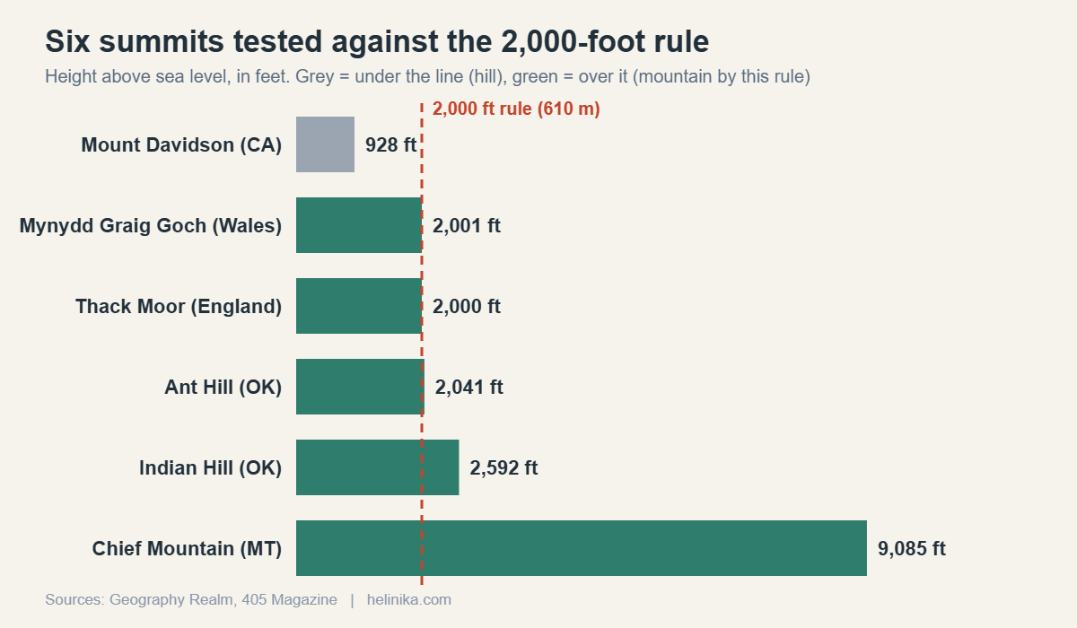
The UK-style rule uses height only, so anyone can test it with a calculator. Let’s run six well-known summits through it and see which label each one earns.
Step 1: Gather the heights
| Summit | Height (ft) | Height (m) | Source |
|---|---|---|---|
| Mount Davidson, San Francisco | 928 | 283 | Geography Realm |
| Mynydd Graig Goch, Wales | 2,000.5 (2,000 ft 6 in) | 609.75 | Geography Realm |
| Thack Moor, England | about 2,000.1 | 609.62 | Geography Realm |
| Ant Hill, Oklahoma | 2,041 | 622 | 405 Magazine |
| Indian Hill, Oklahoma | 2,592 | 790 | 405 Magazine |
| Chief Mountain, Montana | 9,085 | 2,769 | Geography Realm |
Sources: Geography Realm and 405 Magazine. The meter values for the two Oklahoma hills are converted from feet (1 ft = 0.3048 m).
Step 2: Convert the threshold
Multiply 2,000 feet by 0.3048 to get the cutoff in meters:
2,000 × 0.3048 = 609.6 m
That matches the 610 m figure Geography Realm gives for UK practice.
Step 3: Subtract the cutoff from each height
A positive margin means the summit clears the line. A negative margin means it falls short.
| Summit | Height minus 609.6 m | Result by the 2,000-ft rule |
|---|---|---|
| Mount Davidson | −326.7 m | Hill |
| Mynydd Graig Goch | +0.15 m | Mountain |
| Thack Moor | +0.02 m | Mountain |
| Ant Hill | +12.5 m | Mountain |
| Indian Hill | +180.4 m | Mountain |
| Chief Mountain | +2,159.5 m | Mountain |
Step 4: Turn the thin margins into percentages
Mynydd Graig Goch clears the line by 0.15 m. As a share of the cutoff, that is 0.15 ÷ 609.6 ≈ 0.025%. Thack Moor clears it by 0.02 m, or about 0.003%. If percentages feel rusty, see our guide to calculating a percentage.
Step 5: Read the result
Here’s the surprise. The gap between “hill” and “mountain” for Mynydd Graig Goch is 15 centimeters, about the length of a pencil. The land didn’t change in 2008. Only the label did.
Chief Mountain stands 4.5 times the cutoff (9,085 ÷ 2,000 ≈ 4.54), while Mount Davidson reaches only 46% of it (928 ÷ 2,000), 1,072 feet short.
Notice the oddity in the middle. “Mount” Davidson fails the test, yet Ant Hill and Indian Hill, which have “hill” in their names, pass it. Names come from local custom, not from a formula.
Note: this tests height only. Relief and prominence could tell a different story for each summit.
Names Don’t Follow the Rules
Oklahoma shows how loose naming can be. 405 Magazine reports that signs on Cavanal Hill call it “The World’s Highest Hill,” at 1,999 feet, while the state has other summits called hills that are taller, including Indian Hill (2,592 feet), Bonham Hill (2,142 feet) and Ant Hill (2,041 feet).
The same article notes the U.S. has no official height line between the two words. In practice, a hill often becomes a mountain when people start calling it one.
Common Myths About Mountains and Hills
| Myth | Reality |
|---|---|
| A mountain is anything over 1,000 feet | That was the old U.S. relief rule, and it was dropped in the early 1970s |
| One official worldwide height separates them | None exists. The UK uses about 2,000 feet, and scientists use classes |
| Height alone decides the label | Local relief and prominence matter too |
| If the name says “Mount,” it’s a mountain | Mount Davidson is 928 feet, well under the 2,000-foot line |
| A hill can’t be taller than a mountain | Ant Hill (2,041 ft) is more than twice as tall as Mount Davidson (928 ft) |
Frequently Asked Questions
How tall must a hill be to count as a mountain?
There is no official height. The old U.S. rule was 1,000 feet of local relief, dropped in the early 1970s. UK practice generally uses about 2,000 feet (610 m). Which number applies depends on the country, the map maker and local custom.
Is a mountain always taller than a hill?
Usually, but not by name. Ant Hill in Oklahoma is 2,041 feet, while Mount Davidson in San Francisco is 928 feet. Names follow local habit, so a place called a hill can be taller than one called a mountain.
Can a hill be reclassified as a mountain?
Yes, and it has happened. Geography Realm reports that Mynydd Graig Goch in Wales and Thack Moor in England were remeasured with GPS and moved into the mountain category after clearing the 2,000-foot line by centimeters. One of these surveys took about 7,000 GPS readings over two hours.
What counts as a mountain scientifically?
Scientists use classes instead of one cutoff. In the UNEP-WCMC system, land above 2,500 m counts as mountain by elevation alone. At 300 to 1,000 m, an area needs more than 300 m of local relief within a 7 km radius.
Why do some mountains have “hill” in their name, or the reverse?
Because names come from local use, often long before anyone measured. Britannica says the word mountain has no standardized geological meaning, and Geography Realm cites Mount Davidson as a local “mountain” in a flat area.
Is prominence better than height for telling them apart?
Neither is official. Prominence helps rank separate summits: hill lists such as the Marilyns require 150 m. It can also surprise you. Much Better Adventures notes that some Snowdonia peaks have low prominence because they stand close in height to their neighbors.
Conclusion
A mountain is generally bigger, steeper and higher above its surroundings than a hill, but no official line settles every case. Height, local relief and prominence each give a different answer, and local naming often overrides all three.
Next time you see a sign claiming a hill or a mountain, ask one question: measured from what, sea level, the base or the next pass?
Disclaimer
This article is for general educational purposes only. Heights and thresholds vary by source, country and survey date, and the relief example is illustrative. For hiking or navigation, use official maps and local guidance.