

The afternoon starts bright. Then, within an hour, puffy white clouds swell into a towering wall that turns gray, then almost black. The wind picks up, and you know what’s coming. But the cloud is still made of water, and water isn’t black. So where does the darkness come from?
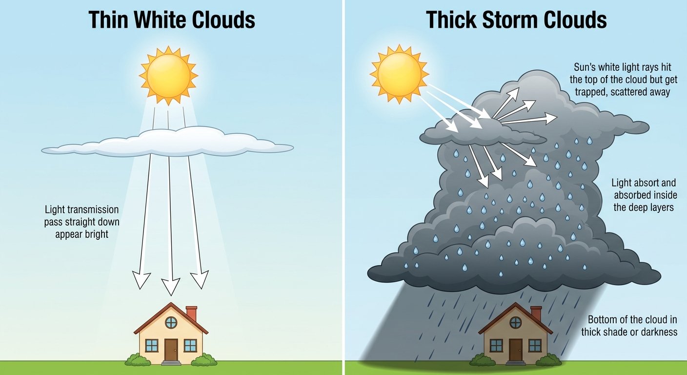
Here is the short answer to why do clouds turn black before it rains: rain clouds aren’t really black. They’re so thick and packed with water that sunlight gets scattered back up and out the sides before it can reach the bottom. From below, you’re looking at the cloud’s shadowed underside, so it looks dark.
A white cloud and a black storm cloud are made of the same stuff. The difference is how much of it there is.
In this guide you’ll learn why clouds are white in the first place, what makes them darken, a step-by-step light model, how tiny droplets grow into raindrops, and what dark clouds can and can’t tell you about the weather.
Quick Info
| Topic | Detail |
|---|---|
| Short answer | Thick clouds block sunlight from reaching their base, so we see their shadowed underside |
| Are rain clouds truly black? | No; they’re white on top and dark only underneath |
| Main cause | Cloud thickness and how densely packed the water droplets are |
| Cloud droplets vs raindrops | About a million cloud droplets make one raindrop |
| Darkest rain clouds | Cumulonimbus (thunderstorm clouds), which can reach 40,000 to 60,000 feet tall |
| Common mistake | Thinking dirt or smoke makes rain clouds dark |
| Reading time | About 10 minutes |
Why Are Clouds White in the First Place?
To understand dark clouds, start with white ones.
A cloud is a huge crowd of tiny water droplets (or ice crystals) floating in the air, and those droplets scatter every color of sunlight about equally, which is why a thin cloud looks white.
Sunlight is a mix of all colors. Air molecules are tiny and scatter mostly blue light, which gives us a blue sky. Our guide on why the sky is blue explains that part. Cloud droplets are much bigger than air molecules, so they scatter red, green and blue light almost equally. Mix all the colors back together, and you get white.
Think of a cloud like a giant pile of tiny glass beads. Each bead bounces light in a new direction. Shine a flashlight on a thin layer of beads and it glows white. Make the pile deep enough, though, and very little light reaches the bottom.
How small are cloud droplets?
Tinier than you’d guess. A typical cloud droplet is only about 10 micrometers wide. That’s roughly one-tenth the width of a human hair.
A typical cloud also holds about 1,000 droplets in every cubic centimeter, a space about the size of a sugar cube.
Those figures come from Penn State’s METEO 300 lesson on cloud physics, a university meteorology course that walks through how droplets form and grow.
Why Rain Clouds Look Dark
A rain cloud darkens for a few connected reasons. None of them involves the cloud turning a different color.
Reason 1: The cloud gets much thicker
Fair-weather clouds are often only a few hundred to a few thousand feet thick. A storm cloud can stretch from near the ground to the top of the lower atmosphere. The more cloud sunlight has to cross, the more of it gets scattered away before it reaches the bottom.
The top of a tall storm cloud still glows bright white in sunshine. Pilots flying above one see a brilliant white surface. Only people underneath see the dark base.
Reason 2: The droplets get more crowded
Before rain falls, clouds collect more and more water. More droplets packed into the same space means more scattering. Light bounces around so many times that much of it escapes out the top and sides instead of passing straight through.
Reason 3: You’re looking at a shadow
When you stand under a thick cloud, you’re looking up at its underside. Very little direct sunlight reaches that side, so it looks gray. If the cloud is thick enough, the base can look nearly black, especially against brighter sky nearby.
It’s a lot like standing under a big tree. Its leaves are green, but the shade underneath looks dark because the leaves block the light.
Reason 4: Water absorbs a little light too
Water isn’t perfectly clear. It soaks up a small share of light, especially red. In a thin cloud, that barely matters. In a deep storm cloud filled with water and growing raindrops, the small losses add up.
That’s the same reason a glass of water looks clear but the deep ocean looks blue. Our guide on why the ocean is blue if water is clear shows how small amounts of absorption pile up with depth.
Worked Example: Follow Sunlight Down Through a Cloud
Let’s put numbers on this with a simple model. The values below are illustrative, chosen to show the pattern. Real clouds are messier, but the idea holds.
Step 1: Set a simple rule
Imagine that every 1 kilometer (about 3,280 feet) of cloud lets through half of the sunlight that enters it from above. The other half gets scattered back up or out the sides.
Step 2: Write the formula
Each extra kilometer cuts the light in half again, so the light reaching the cloud base is:
light at the base = 100% × 0.5^(thickness in km)Here, 100% is the sunlight hitting the top of the cloud, 0.5 is “half gets through each kilometer,” and the small raised number means you multiply by 0.5 once for every kilometer.
Step 3: Try different clouds
| Cloud | Thickness (illustrative) | Light reaching the base | How it looks from below |
|---|---|---|---|
| Thin, puffy fair-weather cloud | 0.5 km | 70.7% | Bright white |
| Ordinary cumulus | 1 km | 50.0% | White with a gray base |
| Thick rain cloud | 3 km | 12.5% | Medium to dark gray |
| Heavy storm cloud | 6 km | 1.6% | Very dark gray |
| Tall thunderstorm | 12 km | 0.02% | Nearly black |
Step 4: Read the result
The thin cloud lets most of the light through, so it glows white. By 3 kilometers, only about one-eighth of the light reaches the base. A thunderstorm 12 kilometers tall (about 40,000 feet) lets through roughly 2 parts in 10,000.
The cloud didn’t change color. It just got deep enough to throw a very dark shadow on itself.
From Cloud Droplet to Raindrop
Dark clouds often go with rain because the same things that darken a cloud, lots of water and great thickness, also help raindrops form.
Step 1: Water vapor needs a seed
Warm, moist air rises and cools. Much of that moisture evaporated from the sea, from one of Earth’s five oceans or a smaller body of water. That invisible vapor needs something to stick to. Tiny particles of dust, salt and smoke, called cloud condensation nuclei, give it a starting point. They’re only about 0.1 micrometers wide.
Step 2: Droplets form
Water condenses on those seeds to make cloud droplets about 10 micrometers wide. They’re so small and light that rising air easily holds them up.
Step 3: Droplets bump and merge
Inside the cloud, droplets collide and join together, a process called collision-coalescence. Penn State’s course notes that most precipitation comes from this process.
Step 4: A raindrop is born
A typical raindrop is about 1 millimeter wide, roughly 100 times wider than a cloud droplet. Because volume grows with the cube of the width, that takes a lot of droplets:
droplets per raindrop = (raindrop width ÷ droplet width)³
                      = (1,000 µm ÷ 10 µm)³
                      = 100³
                      = 1,000,000
Here, µm means micrometers, and the small ³ means you multiply the number by itself three times. So about one million cloud droplets join to make one ordinary raindrop.
Once drops get that big, rising air can’t hold them up anymore, and they fall as rain.
Which Clouds Bring Rain?
Not every gray cloud rains, and not every rain cloud looks the same. Here are the main ones to know.
| Cloud type | What it looks like | Weather it usually brings |
|---|---|---|
| Cumulus | Puffy white clouds with flat bases | Fair weather |
| Stratus | Flat gray sheet, low in the sky | Overcast, maybe drizzle |
| Altostratus | Gray or blue-gray sheet, mid-level | Can lead to steady rain or snow |
| Nimbostratus | Thick, dark gray layer that hides the Sun | Continuous rain or snow |
| Cumulonimbus | Towering, dark-based cloud, often with a flat “anvil” top | Thunderstorms, heavy rain, possibly hail and tornadoes |
NOAA’s SciJinks education site lists nimbostratus and altostratus as the gray, mid-level clouds that usually mean continuous rain or snow, and cumulonimbus as the towering clouds that signal thunderstorms.
You can see the full list in SciJinks’ guide to the different types of clouds, which is part of NOAA’s student science site.
How tall do storm clouds get?
Thunderstorm clouds are the giants of the sky. The National Weather Service says that in a storm’s mature stage, the cloud often reaches 40,000 to 60,000 feet (12 to 18 kilometers) deep.
That figure comes from the National Weather Service’s thunderstorm life cycle guide for storm spotters, which also notes that a single thunderstorm cell usually lasts 30 to 60 minutes.
That’s why these clouds can look nearly black underneath. Sunlight would have to push through miles of water droplets to reach the bottom.
How to Read a Dark Sky
Dark clouds are a useful clue, but they’re not a guarantee. Use these signs together.
- Watch the color change. A cloud base going from white to gray to dark gray is usually getting thicker and wetter.
- Look for height. Clouds that grow tall and bubbly, like cauliflower, are building upward fast and may become thunderstorms.
- Spot the anvil. A flat, spreading top on a tall cloud is a classic sign of a mature thunderstorm.
- Feel the wind. A sudden cool gust often arrives just ahead of storm rain, as falling rain drags cold air down with it.
- Check a forecast. Your eyes can’t see radar. A local forecast or weather alert gives the real picture.
Common Myths About Dark Clouds
| Myth | Reality |
|---|---|
| Rain clouds are black because they’re dirty | Darkness comes mainly from thickness and shadow, not dirt or smoke |
| Storm clouds are dark all over | Their tops are bright white in sunlight; only the base looks dark |
| Dark clouds always mean rain | Thick gray clouds can pass without rain, and light rain can fall from paler clouds |
| Clouds are made of water vapor | They’re made of liquid droplets or ice; water vapor itself is invisible |
| Raindrops are tear-shaped | Small raindrops are nearly round; larger ones flatten on the bottom as they fall |
| The darker the cloud, the closer it is | Darkness depends on thickness and lighting, not distance |
Frequently Asked Questions
Are rain clouds actually black?
No. A rain cloud is made of the same white-scattering water droplets as a fair-weather cloud. It looks dark from below because it’s so thick that very little sunlight reaches its base. Seen from above, by a pilot or from space, the same cloud looks bright white. The “black” you see is really a deep shadow.
Why are some clouds white and others gray on the same day?
It comes down to thickness and lighting. A thin cloud lets plenty of light through and glows white. A thicker cloud nearby blocks more light, so its base looks gray. Where the Sun sits matters too: the side of a cloud facing the Sun looks bright, while the far side and the bottom sit in shadow.
Do dark clouds always mean rain is coming?
Not always. Dark clouds tell you a cloud is thick and full of water, which makes rain more likely. But a thick gray layer can drift by without a drop, and rain can fall from clouds that don’t look very dark. For real planning, check a local forecast or weather radar instead of relying on color alone.
Why do clouds sometimes look green before a storm?
Some very tall thunderstorms take on a greenish tint, especially late in the day. Scientists think it happens when reddish sunset light passes through the deep blue-tinted water of a huge storm cloud, and the mix looks green. A green sky doesn’t guarantee hail or a tornado, but it usually means a very deep, strong storm, so take shelter if warnings are issued.
How much water is in a cloud?
More than you might think, but it’s spread out. Penn State’s cloud physics course gives typical cloud liquid water content of 0.1 to 0.9 grams per cubic meter. That’s less than a gram in a space the size of a washing machine box, yet across a whole cloud many miles wide, it adds up to a huge amount of water.
Why does it get dark and windy right before a storm?
As a thunderstorm grows tall, its thick body blocks sunlight, so the ground below gets noticeably dimmer. Once rain starts falling, it drags cool air down with it. That cool air hits the ground and spreads out as a gust front, which is why a strong, chilly breeze often arrives just before the heaviest rain.
Conclusion
Clouds turn dark before rain because they grow thick and crowded with water droplets. Those droplets scatter sunlight so many times that little reaches the base, leaving the underside in shadow. The cloud is still white on top. It’s just deep enough to darken itself, and that same depth and water help a million tiny droplets merge into each raindrop.
Next time the sky darkens, ask yourself: how much cloud is the sunlight trying to get through? The deeper the cloud, the darker the base, and the closer you may be to rain.
Disclaimer
This article is for general educational purposes only. The cloud thicknesses and light percentages in the worked example come from a simple illustrative model. Cloud color is not a reliable storm warning: always follow official forecasts and alerts from the National Weather Service, and seek shelter indoors when thunder is heard.