

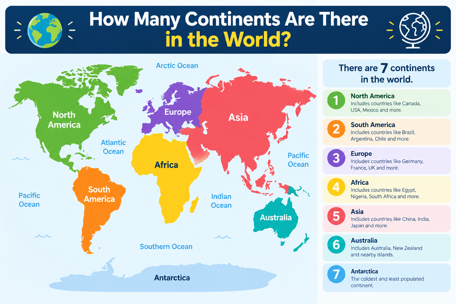
Ask a classroom how many continents there are, and most hands will shoot up with the same answer: seven.
But ask the same question in Spain, Brazil, or Greece, and you might hear six. Look at the Olympic rings, and you’ll count five. Some geographers even argue for four.
So who’s right?
The surprising truth is that all of them are, depending on how you define a continent. This guide explains the standard answer, why other countries count differently, and the key facts about every continent on Earth.
Continents At a Glance
| Detail | Information |
|---|---|
| Most Common Answer | 7 continents |
| The 7 Continents (Largest to Smallest) | Asia, Africa, North America, South America, Antarctica, Europe, Australia |
| Other Models | 6, 5, or 4 continents |
| Largest Continent | Asia (almost one-third of Earth’s land) |
| Smallest Continent | Australia |
| Only Continent With No Permanent Residents | Antarctica |
| Total Continental Land | About 148 million km² (57 million sq mi) |
| Ocean Coverage | Almost three-fourths of Earth’s surface |
| Target Readers | Students, quiz lovers, curious readers, general knowledge learners |
The Short Answer: There Are 7 Continents
The most widely taught answer, used across the English-speaking world and in countries like China, India, and Pakistan, is seven continents.
National Geographic’s education guide on continents defines a continent as one of Earth’s seven main divisions of land and lists them from largest to smallest: Asia, Africa, North America, South America, Antarctica, Europe, and Australia. It adds that geographers usually include each continent’s nearby islands, so Japan counts as part of Asia, while Greenland and the Caribbean islands belong to North America. Together, the continents cover roughly 148 million square kilometers of land.
The 7 Continents in Order of Size
| Rank | Continent | Approx. Area | Quick Fact |
|---|---|---|---|
| 1 | Asia | ≈ 44.6 million km² | Home to about 60% of the world’s people |
| 2 | Africa | ≈ 30.3 million km² | Contains the world’s largest hot desert, the Sahara |
| 3 | North America | ≈ 24.7 million km² | Includes Greenland, the world’s largest island |
| 4 | South America | ≈ 17.8 million km² | Home to the Amazon rainforest |
| 5 | Antarctica | ≈ 14.2 million km² | No permanent human population |
| 6 | Europe | ≈ 10.2 million km² | Only about 7% of Earth’s land |
| 7 | Australia / Oceania | ≈ 8.5 million km² | Smallest and flattest continent |
Note: Area figures are approximate and vary slightly between sources depending on how islands are counted.
Easy memory trick: “All Animals Need Some Air, Even Ants” = Asia, Africa, North America, South America, Antarctica, Europe, Australia.
Why Do Some People Say 6, 5, or 4 Continents?
Here’s the twist. There is no single global authority that officially decides how many continents exist. A continent isn’t defined by one strict scientific rule. It’s partly geography, partly geology, and partly culture and history.
Britannica’s entry on continents describes a continent as one of the larger continuous masses of land and lists the same seven in order of size. But Britannica also points out that Europe and Asia are sometimes treated as a single continent called Eurasia. That one detail explains why the count changes across the world.
Here are the four main models:
The 7-Continent Model
Asia, Africa, North America, South America, Antarctica, Europe, Australia
- Used in the US, UK, China, India, Pakistan, and many other countries
- The most common model in schools worldwide
The 6-Continent Model (Version 1: Eurasia)
Eurasia, Africa, North America, South America, Antarctica, Australia
- Combines Europe and Asia into one landmass
- Popular in Russia and parts of Eastern Europe
- Geologically logical, since Europe and Asia sit on one continuous piece of land
The 6-Continent Model (Version 2: America)
America, Europe, Asia, Africa, Antarctica, Australia/Oceania
- Combines North and South America into one continent
- Widely taught in Latin America, Spain, Portugal, Italy, Greece, and other countries
The 5-Continent Model
Africa, America, Asia, Europe, Oceania
- Counts only the inhabited continents, leaving out Antarctica
- Famously represented by the five Olympic rings
The 4-Continent Model
Afro-Eurasia, America, Antarctica, Australia
- Joins Africa, Europe, and Asia into one giant landmass
- Based on physical connections, since these three are linked by land
Quick Comparison Table
| Model | Count | What’s Combined | Where It’s Common |
|---|---|---|---|
| Standard | 7 | Nothing | English-speaking world, South Asia, China |
| Eurasia | 6 | Europe + Asia | Russia, Eastern Europe |
| America | 6 | North + South America | Latin America, Southern Europe |
| Olympic | 5 | Americas combined, Antarctica excluded | Olympic symbolism |
| Afro-Eurasia | 4 | Africa + Europe + Asia, Americas | Some geographic models |
Bottom line: For most exams and quizzes, the answer is 7. But knowing the other models makes you sound like a true geography expert.
Why Is Europe Separate From Asia?
This is one of the most interesting questions in geography.
Physically, Europe and Asia form one huge landmass. There’s no ocean between them. Their separation is mostly cultural and historical, not geological.
Geographers usually draw the dividing line along:
- The Ural Mountains in Russia
- The Ural River
- The Caspian Sea
- The Caucasus Mountains
- The Black Sea
That’s why countries like Russia, Kazakhstan, and Turkey sit partly in Europe and partly in Asia.
A Closer Look at Each Continent
1. Asia: The Giant
- Largest continent by both area and population
- Covers almost one-third of Earth’s land
- Home to about 60% of the world’s people
- More than 40 countries, including China, India, Pakistan, and Indonesia
- Contains Mount Everest, Earth’s highest point at over 8,700 meters
- Also has Earth’s lowest land point, the shores of the Dead Sea, more than 390 meters below sea level
Fun fact: More than 50 of the world’s highest peaks are in Asia, making it the most mountainous continent.
2. Africa: The Cradle of Humanity
- Second-largest continent
- Stretches about 8,000 km from north to south
- Most lists count 54 countries, though National Geographic lists 56
- Home to the Sahara, the world’s largest hot desert
- The Nile, often called the world’s longest river, flows over 6,560 km
- Central-eastern Africa is where scientists believe early humans first evolved
Fun fact: Africa’s Great Rift Valley is slowly splitting the continent into two tectonic plates.
3. North America: Land of Extremes
- Third-largest continent
- Includes Canada, the United States, Mexico, Central America, the Caribbean, and Greenland
- Greenland is the world’s largest island
- The Great Lakes form the planet’s largest area of fresh water
- Has more climate variety than any other continent, from Arctic ice to tropical rainforests
Fun fact: At its narrowest point in Panama, North America is just 50 km wide.
4. South America: The Wild Continent
- Fourth-largest continent
- 12 independent countries, including Brazil, Argentina, and Colombia
- The Andes are the world’s longest mountain range on land
- The Amazon River carries more water than any other river on Earth
- Angel Falls in Venezuela is the world’s tallest waterfall, dropping more than 979 meters
Fun fact: North and South America only became connected about 3 million years ago.
5. Antarctica: The Frozen Frontier
- Fifth-largest continent, bigger than Europe or Australia
- The coldest, windiest, and driest place on Earth
- Almost entirely covered by ice, in places up to 3.2 km thick
- No countries and no permanent residents, only rotating scientists and support staff
- Governed by the Antarctic Treaty of 1959, which limits the continent to peaceful research
Fun fact: Temperatures here can plunge below −73°C (−100°F).
6. Europe: Small but Mighty
- Sixth-largest continent, covering only about 7% of Earth’s land
- Slightly larger than the country of Canada
- More than 40 countries
- Despite its small size, its population is more than double South America’s
- Famous for the Alps, its youngest and steepest mountains
Fun fact: Most European countries have access to the sea, which shaped centuries of trade and exploration.
7. Australia / Oceania: The Island Continent
- Smallest continent, just under 8.5 million km²
- The flattest continent and the second-driest after Antarctica
- Often called Oceania when including the Pacific islands of Melanesia, Micronesia, and Polynesia
- Home to unique animals like the koala, kangaroo, platypus, and Tasmanian devil
- The Great Barrier Reef is the world’s largest coral reef system
Australia vs Oceania: “Australia” can mean the country or the continent. “Oceania” is a broader region that includes Australia, New Zealand, Papua New Guinea, and thousands of Pacific islands. Many schools now use “Australia/Oceania” to avoid confusion.
Continents by the Numbers
Let’s put the world’s land into perspective with a little math.
Earth’s total surface area is about 510 million km². You can actually calculate this yourself using the sphere surface area formula, SA = 4πr², with Earth’s average radius of about 6,371 km. Try it with the formulas in our Geometry Formulas Cheat Sheet: Area, Volume & Perimeter Made Easy.
Now, if continents cover about 148 million km²:
Land share = (148 ÷ 510) × 100 ≈ 29%So roughly 29% of Earth is land and about 71% is water. Want to practice calculations like this? See How to Calculate Percentage: A Step-by-Step Guide with Examples.
Did the Continents Always Look Like This?
Not at all. Continents are always moving, very slowly, on giant slabs of rock called tectonic plates.
- About 240 million years ago, almost all of Earth’s land was joined in one supercontinent called Pangaea.
- About 200 million years ago, Pangaea began breaking apart.
- Over millions of years, the pieces drifted into the continents we know today.
- Even now, North America and Europe move apart by about 2.5 cm (1 inch) every year, roughly the speed your fingernails grow.
Scientists believe the continents may one day join together again into a new supercontinent.
Is There an 8th Continent?
You may have heard of Zealandia, sometimes called the “hidden eighth continent.”
Zealandia is a huge piece of continental crust in the South Pacific. About 94% of it lies underwater. Only small parts stick up above the sea, including New Zealand and New Caledonia.
In 2017, a team of geologists argued that Zealandia meets the scientific requirements to be called a continent. However, because it’s mostly submerged, it isn’t included in the standard list taught in schools.
So for now, the classroom answer stays at seven.
Continents vs Oceans
People often mix up continents with oceans. Here’s how they compare:
| Continents (Land) | Oceans (Water) |
|---|---|
| Asia | Pacific Ocean (largest) |
| Africa | Atlantic Ocean |
| North America | Indian Ocean |
| South America | Southern (Antarctic) Ocean |
| Antarctica | Arctic Ocean (smallest) |
| Europe | |
| Australia |
7 continents and 5 oceans. The ocean area is more than double the area of all the continents combined.
Imaginary Lines That Cross the Continents
Geographers use lines measured in degrees to locate places on continents:
- Equator (0°): Crosses Africa, South America, and Asia (Indonesia)
- Prime Meridian (0° longitude): Passes through Europe and Africa
- Antarctic Circle (66.5° South): Surrounds Antarctica
- Arctic Circle (66.5° North): Crosses North America, Europe, and Asia
Latitude and longitude are simply angles measured from Earth’s center. If you’d like to understand how angles work, read Understanding Angles: Acute, Obtuse, Right, and Straight Angles Explained.
Quick Quiz: Test Your Knowledge
- Which is the largest continent?
- Which continent has no permanent human population?
- Which continent is crossed by both the Equator and the Prime Meridian?
- Which two continents are combined in the “Eurasia” model?
- What do the five Olympic rings represent?
- What is the name of the mostly underwater “hidden continent”?
Answers:
- Asia
- Antarctica
- Africa
- Europe and Asia
- The five inhabited continents
- Zealandia
Frequently Asked Questions
How many continents are there in the world?
Most commonly, 7: Asia, Africa, North America, South America, Antarctica, Europe, and Australia. Some countries teach 6, 5, or 4 depending on their model.
Which is the largest continent?
Asia, covering almost one-third of Earth’s land and home to about 60% of the world’s population.
Which is the smallest continent?
Australia (often grouped as Australia/Oceania).
Why do some countries teach 6 continents?
Some combine Europe and Asia into Eurasia. Others combine North and South America into one continent called America.
Is Antarctica a continent?
Yes. It’s the fifth-largest continent, though it has no countries or permanent residents.
Which continent has the most countries?
Africa, with 54 countries in most lists.
Is Greenland a continent?
No. Greenland is the world’s largest island and is part of the North American continent.
Is Zealandia the 8th continent?
Some geologists say it qualifies scientifically, but because it’s about 94% underwater, it isn’t part of the standard seven.
Final Thoughts
So, how many continents are there? The most common answer is seven: Asia, Africa, North America, South America, Antarctica, Europe, and Australia.
But geography isn’t always black and white. Depending on where you grew up, you may have learned six, five, or even four. Each model is based on a different way of looking at the world, whether physical connections, culture, or history.
Next time someone asks, you can give the classic answer and explain why it’s more interesting than it seems.
Sources:
📘 Disclaimer
This article is for general informational and educational purposes only. Continent definitions, area figures, and country counts can vary between sources, educational systems, and international organizations. Population and geographic data may change over time. For academic work, always follow the definitions and figures used by your teacher, textbook, or examination board.